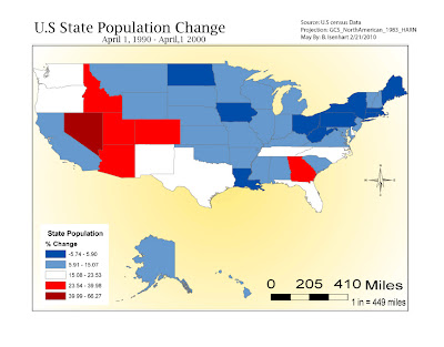
 This map of the US State Population % Change from April 1.1990- April1, 2000. It took alittle bit to get things moved around after I transferred my map from ArcMap. I'm still trying to figure out the layers section of AI, just seems to me there's a lot of different features and sometimes I click on the wrong line and I move something I don't nesscessairly want to move. Other than that I'm learning and having fun doing it.
Sunday, February 21, 2010
US State Population Map #1
 This map of the US State Population % Change from April 1.1990- April1, 2000. It took alittle bit to get things moved around after I transferred my map from ArcMap. I'm still trying to figure out the layers section of AI, just seems to me there's a lot of different features and sometimes I click on the wrong line and I move something I don't nesscessairly want to move. Other than that I'm learning and having fun doing it.
Subscribe to:
Post Comments (Atom)

No comments:
Post a Comment